 Hocking Hills
Where all the best roads lead . . .HIKE. STAY. PLAY. YOUR HOCKING HILLS ADVENTURE BEGINS HERE!
Buy our Guidebooks!
Hocking Hills
Where all the best roads lead . . .HIKE. STAY. PLAY. YOUR HOCKING HILLS ADVENTURE BEGINS HERE!
Buy our Guidebooks!

- Home
- Hiking
- Ash Cave
- Cedar Falls
- Old Man's Cave
- Whispering Cave
- Conkle's Hollow
- Cantwell Cliffs
- Rock House
- Hidden Waterfalls
- Rose Lake at Old Man's Cave
- Ash Cave to Cedar Falls
- Balanced Rock/Devil's Tea Table
- Airplane Rock
- Peninsula Trail_Lake Hope State Park
- Hope Furnace Trail-Lake Hope State Park
- Vinton County Parks: Moonville Rail Trail
- Clear Creek Metro Park - Fern Creek Trail
- Clear Creek Metro Park - Cemetery Ridge Hemlock Loop
- Boch Hollow Nature Preserve
- Zaleski Backpack Trail
- Mountain Bike Trails - Old Man's Cave
- Mountain Bike Trails - Lake Hope
- Fall Colors Hiking
- Dog Friendly Trails
- Bigfoot Trails
- Hike the Fringe: Closeby Trails
- Cabins/Lodging
- Camping
- Programs/Events
- Find Your Adventure. Try New Things!
- Hocking Hills Wildflowers
- General Park Information
Hocking Hills Directions and Map:
Hocking Hills Region is located at:
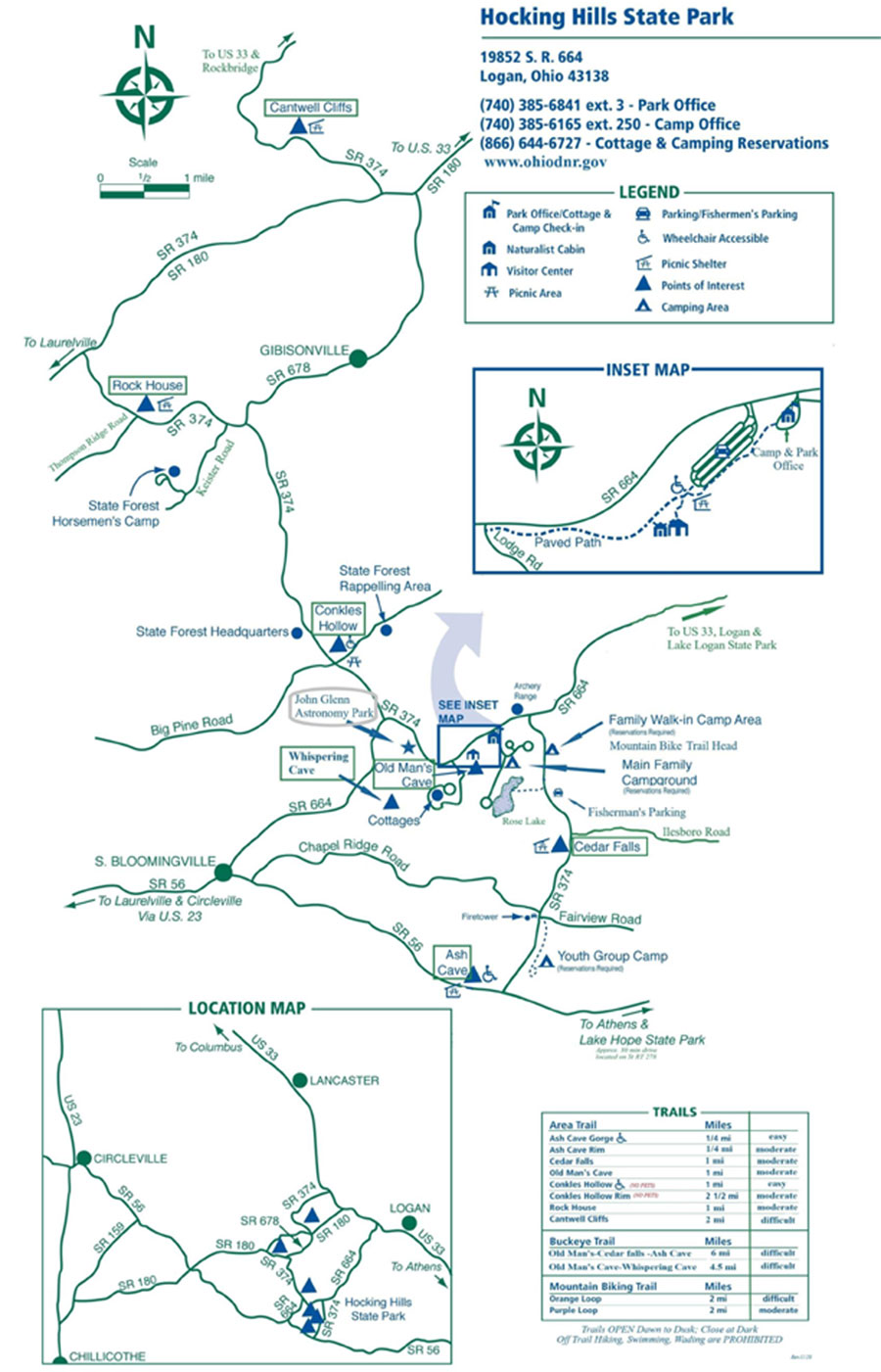
Hocking Hills State Park Directions:
From Cleveland, Ohio:
Take I-71 South to Columbus.
Take 270 East toward Wheeling, WV to U.S. 33 East (Lancaster Exit)
Travel East to Logan, Exit on 664 South.
From Columbus, Ohio:
Take U.S. 33 East through Lancaster to Logan, Ohio and exit onto State Route 664 South
From Cincinnati, Ohio:
Take I-71 North towards Columbus.
Watch for and take State Route 56 East through Mt. Sterling.
Continue on State Route 56 East through Circleville and Laurelville to South Bloomingville, Ohio.
In South Bloomingville take State Route 664 North approximately 4 miles to the park.
From Toledo, Ohio:
Take I –75 South to Findlay, get on State Route 23 to Columbus.
Take I-270 East towards Wheeling to U.S. 33 East (Lancaster Exit).
Travel East to the Logan, Exit 664 South.
From Logan, Ohio:
Take 664 South approximately 12 miles to park area.
Hiking Trail Area Map
OPEN ALL YEAR-ROUND FROM DAWN TO DUSK
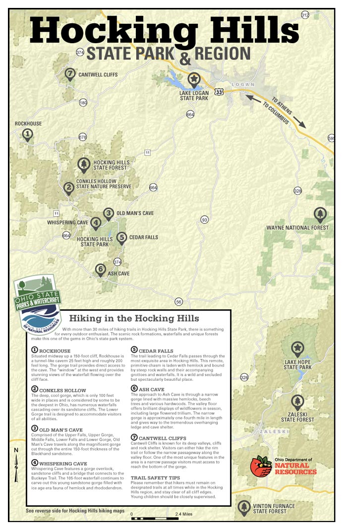
There are seven major hiking areas in Hocking Hills State Park - All are one-way trail systems.
Ash Cave, Old Man's Cave, Rock House, Conkle's Hollow, Cedar Falls, Cantwell Cliffs, and Whispering Cave Trail. These park areas offer a unique experience for those who walk its paths no matter what season (the park is open year-round from dawn to dusk)—located on the southern edge of Hocking County. But those are just a handful. There are many hiking trails in the Hocking Hills include those at Wayne National Forest, Clear Creek Metro Parks, Lake Hope State Park, Vinton County Park District's Moonville Tunnel, and Hocking College's Robbins Crossing (with park programs) and the Athens Hock-Hocking Adena Rail Trail bikeway.