 Hocking Hills
Where all the best roads lead . . .HIKE. STAY. PLAY. YOUR HOCKING HILLS ADVENTURE BEGINS HERE!
Buy our Guidebooks!
Hocking Hills
Where all the best roads lead . . .HIKE. STAY. PLAY. YOUR HOCKING HILLS ADVENTURE BEGINS HERE!
Buy our Guidebooks!


- Home
- Hiking
- Ash Cave
- Cedar Falls
- Old Man's Cave
- Whispering Cave
- Conkle's Hollow
- Cantwell Cliffs
- Rock House
- Hidden Waterfalls
- Rose Lake at Old Man's Cave
- Ash Cave to Cedar Falls
- Balanced Rock/Devil's Tea Table
- Airplane Rock
- Peninsula Trail_Lake Hope State Park
- Hope Furnace Trail-Lake Hope State Park
- Vinton County Parks: Moonville Rail Trail
- Clear Creek Metro Park - Fern Creek Trail
- Clear Creek Metro Park - Cemetery Ridge Hemlock Loop
- Boch Hollow Nature Preserve
- Zaleski Backpack Trail
- Mountain Bike Trails - Old Man's Cave
- Mountain Bike Trails - Lake Hope
- Fall Colors Hiking
- Dog Friendly Trails
- Bigfoot Trails
- Hike the Fringe: Closeby Trails
- Cabins/Lodging
- Camping
- Programs/Events
- Find Your Adventure. Try New Things!
- Hocking Hills Wildflowers
- General Park Information
Cedar Falls Hiking Trail
Official Cedar Falls hiking guide from TheHockingHills.org.
Cedar Falls, 21724 State Route 374, Logan, OH 43138 | GPS Tracking: (39.418265, -82.526295)
Hiked and field-checked for The Hocking Hills Organization by Jannette Quackenbush
Last checked: July 2026
Route checked: Cedar Falls Loop Trail from Trail Marker H to the parking area
GPS-recorded loop: 0.6 mile
GPS device: Garmin GPSMAP 64sx
Difficulty: Moderate; uneven steps descend to the creek area, with additional steps and a rugged path beyond the waterfall
Trail notes: Uneven stone and wooden steps lead down to the creek area. The trail from the creek to Cedar Falls is comparatively easy, but beyond the waterfall hikers encounter additional steps and a more rugged path.
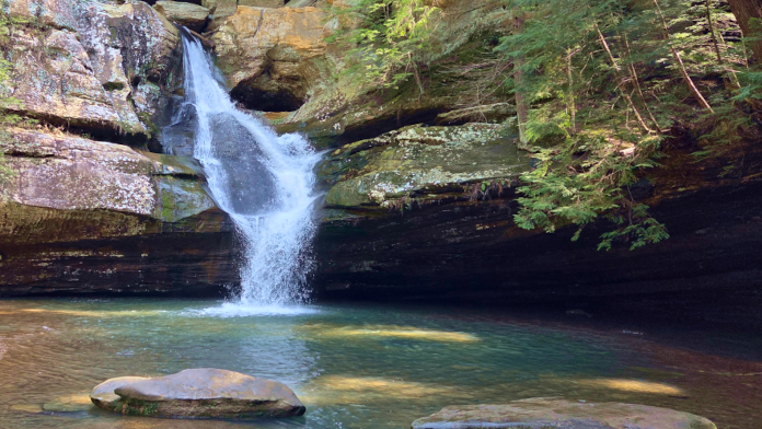
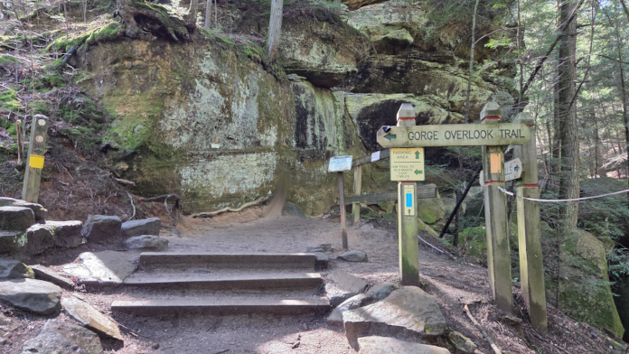
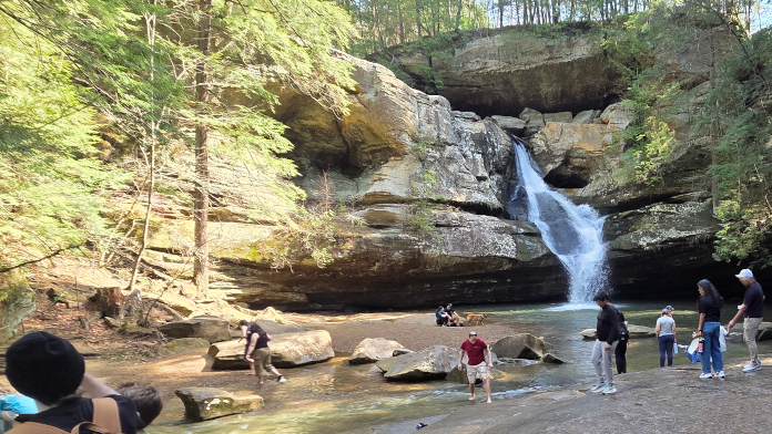
Cedar Falls is one of the seven major hiking areas in Ohio’s Hocking Hills region. The one-way loop begins at Trail Marker H across from the restrooms and descends by uneven stone and wooden steps toward Queer Creek and Cedar Falls.
The GPS-recorded loop is approximately 0.6 mile and generally takes about 40 minutes. The trail from the creek area to the waterfall is comparatively easy, but hikers encounter additional steps and a more rugged path beyond the falls before returning to the parking area.
Cedar Falls is a seasonal waterfall, with the strongest flow generally occurring after rain and during wetter seasons. The trail also passes bridges, cliffs, rock formations, and shaded sections of hemlock forest.
Longer trail connections continue from the Cedar Falls area toward Old Man’s Cave and Ash Cave. These extended routes require additional time and should not be confused with the shorter Cedar Falls loop.
Well-behaved, non-aggressive pets are permitted on leash. The trail is not wheelchair or stroller accessible because of its uneven steps, rugged surfaces, and elevation changes. Hikers must remain on marked trails, and there is no wading or swimming in the creek or waterfall.
Cedar Falls History
Cedar Falls is formed by Queer Creek, a stream named by early explorers for its unusual, winding route through the gorge. Shawnee and Delaware peoples once traveled through this area, and local legend tells of a beech tree above the falls carved with, “This is the road to hell, 1782,” reportedly by a captive. The waterfall drops about 50 feet over Blackhand sandstone, deposited more than 300 million years ago, and is surrounded by hemlock, beech, and maple trees. Early settlers mistook the hemlocks for cedars, giving Cedar Falls its name. A sawmill once operated above the waterfall, powered by Queer Creek. Cedar Falls carries one of the park’s strongest water flows and is especially striking after rain or during winter ice formations.
Cedar Falls Trail at a Glance
Loop distance: 0.6 mile
Typical hiking time: About 40 minutes
Difficulty: Moderate
Trail type: One-way loop trail
Wheelchair and stroller access: Not accessible because of uneven steps and rugged terrain
Pets: Permitted on leash
Restrooms: Flush restrooms near the parking area
Main features: Cedar Falls, Queer Creek, bridges, rock formations, hemlock forest, and seasonal water flow
Trail connections: Longer routes continue toward Old Man’s Cave and Ash Cave

Cedar Falls has a seasonal waterfall, most likely to run in spring, winter, and autumn. There are steps and bridges.

The one-way loop trail is approximately 0.6 miles long and takes about 40 minutes to hike. It is open year-round, and pets are permitted on leash.

The trail has steps. There are flushable toilets at the restroom at the parking lot.
The flow of water at Cedar Falls is seasonal, mainly during spring, fall, and winter.
There is no swimming or wading allowed at Cedar Falls or any of the park areas except the beach at Lake Logan.

Hikers visiting Cedar Falls during the annual Winter Hike in January. This is the mid-way point for the hike and thousands attend annually.


Hocking Hills Park Trail Areas

7 major hiking areas of Hocking Hills State Park- Ash Cave, Old Man's Cave, Rock House, Conkle's Hollow, Cedar Falls, Cantwell Cliffs, and Whispering Cave.
Cedar Falls Trail Map
Start at Parking Area. End at Parking Area.
Yellow: Bottom Cedar Falls Trail (Yellow Blazes on Trees)
Red: Top of Gorge Rim Trail (Red Blazes on Trees)
Blue: Grandma Gatewood Trail (Blue Blazes on Trees)
Take the complete route with you. The Hocking Hills Hiking Trail Guidebook includes field-checked directions, GPS coordinates, trail junctions, elevation information, parking details, and route combinations for Cedar Falls and many additional Hocking Hills trails.

Hocking Hills State Park Trails - Cedar Falls
Cedar Falls - Hocking Hills State Park
21401-21421 OH-374Logan, OH 43138
Common Questions About Cedar Falls
How long is the Cedar Falls hiking trail?
The Cedar Falls Loop Trail is approximately 0.6 mile and generally takes about 40 minutes to hike, depending on trail conditions and how long hikers stop at the waterfall.
Is Cedar Falls a difficult hike?
Cedar Falls is a moderate hike. Uneven stone and wooden steps descend to the creek area, and hikers encounter additional steps and a more rugged path beyond the waterfall.
Where does the Cedar Falls trail begin?
The one-way loop begins at Trail Marker H across from the restrooms and descends toward the creek and waterfall.
Does Cedar Falls always have water?
No. Cedar Falls is a seasonal waterfall. Water flow is usually strongest after periods of rain and during wetter seasons, while the falls may be light or dry during extended dry weather.
Is Cedar Falls wheelchair or stroller accessible?
No. The Cedar Falls Loop Trail includes uneven steps, rugged surfaces, and elevation changes and is not wheelchair or stroller accessible.
Are dogs allowed at Cedar Falls?
Yes. Well-behaved, non-aggressive pets are permitted on leash. Owners should consider the uneven steps, rugged trail surfaces, crowds, and changing conditions before bringing a pet.
Are restrooms available at Cedar Falls?
Yes. Flush restrooms are available near the Cedar Falls parking area.
Can hikers continue from Cedar Falls to Old Man’s Cave or Ash Cave?
Yes. Longer trails connect Cedar Falls with Old Man’s Cave and Ash Cave. Detailed junctions, distances, GPS coordinates, and route combinations are included in the Hocking Hills Hiking Trail Guidebook.
Cedar Falls- Hocking Hills State Park
There was once a grist mill running along the creek that makes the waterfall. When crossing the A-Frame Bridge above, look for signs of the old mill.

Part of the 7 trail systems within Ohio's Hocking Hills State Park
Home to the Beans and Cornbread Halfway Point at Hocking Hills Winter Hike.

OPEN ALL YEAR-ROUND FROM DAWN TO DUSK
There are seven major hiking areas in Hocking Hills State Park - All are one-way trail systems.
Click here for a Regional Hocking Hills Trail Area Map
Ash Cave, Old Man's Cave, Rock House, Conkle's Hollow, Cedar Falls, Cantwell Cliffs, and Whispering Cave Trail. These park areas offer a unique experience for those who walk its paths no matter what season (the park is open year-round from dawn to dusk)—located on the southern edge of Hocking County. But those are just a handful. Other hiking trails in the Hocking Hills region include those at Wayne National Forest, Clear Creek Metro Parks, Lake Hope State Park, the Moonville Rail Trail, and the Hockhocking Adena Bikeway.