 Hocking HillsWhere all the best roads lead . . .HIKE. STAY. PLAY. YOUR HOCKING HILLS ADVENTURE BEGINS HERE!
![]()

Hocking HillsWhere all the best roads lead . . .HIKE. STAY. PLAY. YOUR HOCKING HILLS ADVENTURE BEGINS HERE! ![]()
Conkle's Hollow State Nature Preserve 24858 Big Pine Road, Rockbridge, OH 43149 | GPS Tracking: (39.452935, -82.572075)
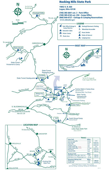
Conkle’s hollow is one of the 7 major hiking trails of Hocking Hills State Park in southern Ohio.
There are 2 Trails to hike, Upper Trail and Lower Trail:
1) Lower Trail is a ¾ mile long, wheelchair-accessible trail. It takes about 1 hour to hike the trail.
2) Upper Trail is a one-way trail that is 2 miles long. This hike may be considered strenuous for those who are not physically fit, do not hike regularly, or have health issues such as knee surgeries or heart problems.
It involves a moderate to steep incline, uneven steps, 70 to 100-foot cliff drops, paths with visible roots, and steep terrain. It is not suitable for young children, unfit adults, or pets.
HIKERS MUST REMAIN ON THE MARKED TRAIL. NO PETS ARE ALLOWED AT CONKLE’S HOLLOW. There is NO wading or swimming allowed in the waterfalls or creeks.


The Lower Trail—wheelchair accessible. Conkle's Hollow has an Upper Trail and a Lower Trail.

The Upper has cliff views, steps, and is strenuous.

The Lower Trail also has small recess caves and a boardwalk.


7 different hiking areas of Hocking Hills State Park- Ash Cave, Old Man's Cave, Rock House, Conkle's Hollow, Cedar Falls, Cantwell Cliffs, and Whispering Cave.
Start at Parking Area. End at Parking Area.
Green: Bottom of Gorge (Green Blazes on Trees)
Red: Top of Gorge Rim Trail (Red Blazes on Trees)
No pets in this preserve!

Conkle's Hollow State Nature Preserve
24858 Big Pine Road Rockbridge, OH 43149
There is a legend that robbers buried treasure somewhere in Conkle's Hollow, the riches of thieves who stashed it there. But do not start digging - you have to stay on the trail at this nature preserve! Instead, visit in the autumn and discover another treasure - Ohio's top leaf peep views on the Upper Trail.


There are seven major hiking areas in Hocking Hills State Park - All are one-way trail systems.
Ash Cave, Old Man's Cave, Rock House, Conkle's Hollow, Cedar Falls, Cantwell Cliffs, and Whispering Cave Trail. These park areas offer a unique experience for those who walk its paths no matter what season (the park is open year-round from dawn to dusk)—located on the southern edge of Hocking County. But those are just a handful. There are many hiking trails in the Hocking Hills include those at Wayne National Forest, Clear Creek Metro Parks, Lake Hope State Park, Vinton County Park District's Moonville Tunnel, and Hocking College's Robbins Crossing (with park programs) and the Athens Hock-Hocking Adena Rail Trail bikeway.